Top Story
2016 Annual Conference
The inaugural ULI UK Annual Conference took place on 24 May 2016 at Goldman Sachs headquarters on Fleet Street, London.
16 May 2016
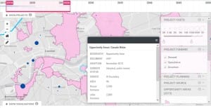
Christopher Choa, Chair of the ULI Infrastructure Council, recently hosted a presentation at London City Hall. ULI invited Jeremy Skinner (GLA, Head of Economic Growth & Enterprise), Andrew McMunnigal (GLA, Senior Policy and Projects Officer for Infrastructure) and Paul Hodgson (GLA, GIS & Infrastructure Manager) to discuss an extraordinary GIS map of London.
The Infrastructure Group at the Greater London Authority (GLA) has developed this new map, which is currently in beta-testing.
No other city has a map of this kind!
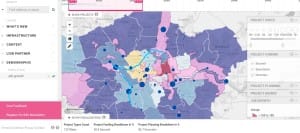
Like many GIS applications, this database integrates an extraordinary amount of infrastructure information in an interactive format, and currently incorporates over 40 major urban opportunity areas (some several times larger than the 2012 Olympic Site), and over 12,000 ongoing and planned project.
What makes this particular digital map so powerful is that for the first time, virtually all of the city’s infrastructure providers (Transport, Power, Water, Sewerage, Broadband, etc.) as well as major developers in the city are updating the digital database every week. And unlike conventional GIS databases, which layer assets and links to related information, this particular platform integrates project data, spatial organisation, and powerful analytics via an interactive dashboard. Users can identify conflicts (e.g. project overlaps with other utilities, interference with view corridors), parallel efforts by other infrastructure providers, and projects occurring in similar timescales. The dashboard allows users to measure consequences of development (e.g. impacts to traffic movements of individual and overlapping projects), identify land ownership and tax base, and even to anticipate employment sectors and vocational training requirements related to particular major initiatives.
Although full access to granular information is restricted (because of commercially sensitive information) to members of the London Infrastructure Delivery Board (the regulated utilities that have contributed to vast majority of the database), higher-level information is now publicly accessible. You can view a brief presentation about the map and trial the beta-test here
The Infrastructure Group at the Greater London Authority recognises advances of machine learning and is managing the introduction of mega-data into the public sector. This particular new tool creates a powerful platform that encourages innovation, suggests cross-sector opportunities across the urban realm, and encourages collaboration between London’s boroughs. It is not hard to imagine the power of this tool, especially when its databases can be merged with proprietary information that ULI members are also organising.
This GIS map is a great model for what city authorities can do for their own territories, anywhere in the world.